By Russell Neyman.
We hear it all the time: Locals who drive through the easternmost section of Port Orchard, along Southworth Drive to the local elementary school or ferry hear us talk of the historic town of Colby — the very first community on the coastline that lay between Annapolis clear down to Olalla — and they correct us with, “You mean, South Colby, don’t you…?”
The answer is, no. The group of buildings at the intersection of Banner and Southworth, just to the east of the Curley Creek Bridge, was technically an subdivision to the original town of Colby, which was located on the beach to the north. The new annex was a major intersection, but did not have a post office during the homesteading years.
The north-facing shoreline along Yukon Harbor had plenty of desirable land, and the original homesteads were established by I.C. Ellis (87 acres, 1883) and Hiram Cornell (166 acres, 1890). Both had filed papers on the lands many years earlier, but only completed the homesteading process when it became apparent that civilization had taken a foothold in the mid 1880’s.
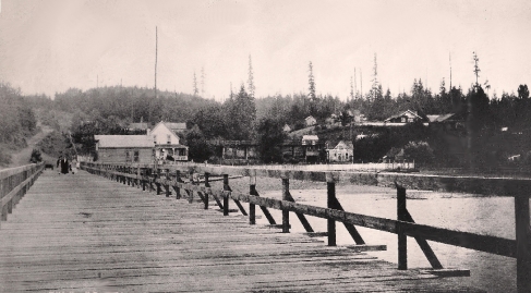
Colby, with a small collection of stores, waterfront businesses, and a hotel, was the headquarters for provisioning and mail. Indeed, one map of the United States showed Colby to be a major metropolis in the midst of a wilderness on a par with Port Angeles and Sidney (Port Orchard). The first pier on Yukon Harbor was built about 1900 at the base of what is now Cole Loop.
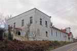
The Curley Creek Grange building, showing the storefront structure used for the main entrance. with the original Adventist Church at the far end serving as a stage. It should be noted that both Southworth Drive and Harvey Street have undergone significant grading since the building was established on a hilltop in the mid 1910’s, and at one time the front entrance was roughly at street level with the roadway. The structure has recently been converted to a residence.
Even with the construction of a 400-foot bridge, the formidable creek made the South Colby area hard to access. The Colby founding fathers were not only devoted to the Temperence Movement (opposed to any consumption of alcohol) but they were mostly Methodists, too. The Cornell families – there were several in the area – were members of the Seventh Day Adventist Church, and must have had their differences with Joseph Squire Grant and John Anspaugh, who held controlling interest in the Colby business sector.
It can’t be documented, but the general belief within our group of historians is that there was quite a political struggle within the community; that there were significant divides between the republicans and democrats, and the various religious factions could have been at odds, too. In any case, it made sense that a secondary community with different ways of doing things would spring up “on the other side of the bridge.”

The Grange Hall from the southwest, showing the small church that was used for the stage. Photos by Russell Neyman.
So in 1889, Hiram Cornell, along with his brother, E.T., decided to establish a separate community to the south. That made sense, since a formal bridge capable of carrying wagons and freight was finally built over the Curley Creek bridge in 1890. They took over controlling interest of the Ellis properties, and encouraged the building of a pier, store, and better roads.
All of this occurred during a building boom in the area, which saw many steamship piers, hotels, stores, blacksmith shops, and lumber mills spring up. With the growth of Manchester (Brooklyn), Harper, and South Colby, and the founding fathers of Colby lost their commercial monopoly.
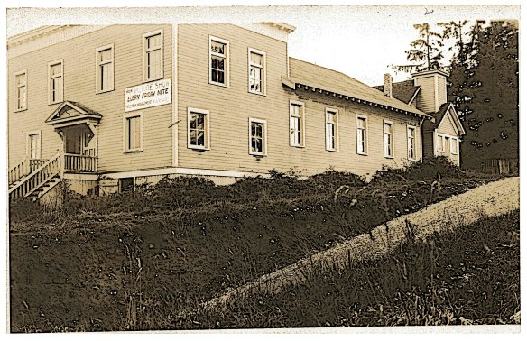
Probably taken in the late `1930’s, this view of the Curley Creek Grange shows the original front entrance. It is hard to date this photo, but we believe it is after the 1929 road and bridge were put in, accounting for the steep slope on Harvey Avenue. The sign on the front reads, “New Picture Show Each Friday; Under New Management.” From the McFate Family Collection.
A few stores were built in the upstart neighborhood, but commerce never really took hold. The Grange Hall was constructed about 1914, re-purposing two existing structures, the original Adventist Church and a two-story store, to create a larger building. The Curley Creek Grange — a local chapter of a national association to promote and organize agriculture — lasted only a few years and the large building was converted into a community meeting hall.
As the decades passed and automobile transportation replaced steamships, Colby withered away, with the last store torn down in the mid 1960’s. Automobile ferry terminals were established in Manchester and Harper, isolating the original commercial center. Now, Colby has virtually vanished, and only a church and a few abandoned stores mark the community known as South Colby, originally Colby’s subdivision.
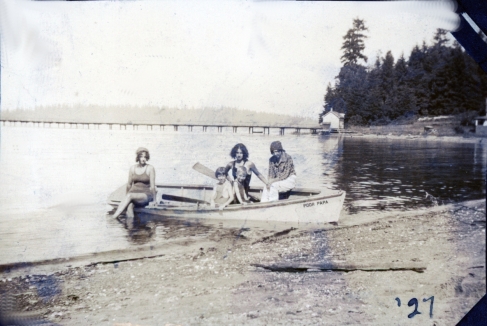
This photo of the McFate girls in their rowboat, Poor Papa, was taken in 1927 and shows the South Colby steamship pier in the background. The structure at the base of the pier was, reportedly, a barber shop. Photo courtesy of the McFate family.

Infomative and well written.